Elkton, MD Hail Storm – November 2026
November 12, 2026 hail storm near Elkton, MD. Radar-confirmed hail track and contractor lead lists available.
Max Hail
1.4"1.5" est.
confirmed
Zones
16
NWS alerts
Radar
6,868
dual-pol hits
Spotter
92
field reports
NWS WARNING AREA · Elkton Metro · Nov 12, 2026
Intelligence Platform
StormSnipe Pro
$49/ mo
Cancel anytime · No contracts
›All 50 states
›No zone limits
›No per-event fees
Subscribe to Pro
Pro renews monthly until canceled · Cancel anytime in the billing portal
What's included
Instant delivery
Every storm published within hours of NOAA confirmation.
Interactive Strike Map
Full radar-confirmed hail track on an interactive map.
Address CSV export
Every affected residential address, export-ready.
Smart alerts
Notified when a storm hits your area. Set zones once.
Nationwide coverage
All 50 states. No zone restrictions. No geographic caps.
Live pipeline
NOAA NEXRAD processed and delivered 24/7.
Address data notice
Pro coverage in California, Vermont, and Oregon includes the confirmed hail track and Strike Map only — no address lists. State data-privacy law treats compiled address lists differently in those three states, so we exclude their addresses from extraction and delivery.
NWS WARNING AREAS · 16
This storm generated 16 NWS alert zones. Pro access covers the complete storm track and all addresses across every zone.
ZONE 1NWS MDC015
Elkton, MD
Dual-Pol Radar
1,494 addresses in warning area
Alert issued Thu, Nov 12 · 5:23 PM UTC
1"
confirmed
1"
est. (NWS)
ZONE 2NWS DEC003
Hockessin, DE
Dual-Pol Radar
601 addresses in warning area
Alert issued Thu, Nov 12 · 5:34 PM UTC
1.5"
confirmed
1"
est. (NWS)
ZONE 3NWS PAC011
Elverson, PA
Dual-Pol Radar
Alert issued Thu, Nov 12 · 5:39 PM UTC
1.5"
confirmed
1"
est. (NWS)
ZONE 4NWS PAC071
Narvon, PA
Dual-Pol Radar
Alert issued Thu, Nov 12 · 5:41 PM UTC
1.5"
confirmed
1"
est. (NWS)
ZONE 5NWS DEC003
Wilmington, DE
Dual-Pol Radar
4,069 addresses in warning area
Alert issued Thu, Nov 12 · 6:11 PM UTC
2"
confirmed
1"
est. (NWS)
ZONE 6NWS DEC003
New Castle, DE
Dual-Pol Radar
1,767 addresses in warning area
Alert issued Thu, Nov 12 · 6:13 PM UTC
1.75"
confirmed
1"
est. (NWS)
ZONE 7NWS PAC011
Pottstown, PA
Dual-Pol Radar
Alert issued Thu, Nov 12 · 6:35 PM UTC
1"
confirmed
1"
est. (NWS)
ZONE 8NWS DEC003
Darby, PA
Dual-Pol Radar
223 addresses in warning area
Alert issued Thu, Nov 12 · 7:11 PM UTC
2"
confirmed
1.06"
est. (NWS)
ZONE 9NWS PAC017
Lower Gwynedd, PA
Dual-Pol Radar
Alert issued Thu, Nov 12 · 7:44 PM UTC
1.5"
confirmed
1"
est. (NWS)
ZONE 10NWS NJC005
Philadelphia, PA
Dual-Pol Radar
Alert issued Thu, Nov 12 · 8:01 PM UTC
1.75"
confirmed
1"
est. (NWS)
ZONE 11NWS NJC019
New Hope, PA
Dual-Pol Radar
Alert issued Thu, Nov 12 · 8:14 PM UTC
1.5"
confirmed
1"
est. (NWS)
ZONE 12NWS NJC005
Bordentown, NJ
Dual-Pol Radar
3,637 addresses in warning area
Alert issued Thu, Nov 12 · 8:37 PM UTC
2"
confirmed
1"
est. (NWS)
ZONE 13NWS NJC005
Columbus, NJ
Dual-Pol Radar
166 addresses in warning area
Alert issued Thu, Nov 12 · 8:40 PM UTC
2"
confirmed
1"
est. (NWS)
ZONE 14NWS NJC005
Allentown, NJ
Dual-Pol Radar
65 addresses in warning area
Alert issued Thu, Nov 12 · 9:03 PM UTC
1.5"
confirmed
1.07"
est. (NWS)
ZONE 15NWS NJC005
Millstone Township, NJ
Dual-Pol Radar
Alert issued Thu, Nov 12 · 9:20 PM UTC
2"
confirmed
1.5"
est. (NWS)
ZONE 16NWS NJC025
Lakewood, NJ
Dual-Pol Radar
7,966 addresses in warning area
Alert issued Thu, Nov 12 · 10:06 PM UTC
2"
confirmed
1.39"
est. (NWS)
A hail-producing storm tracked through Elkton, MD on November 12, 2026, producing 1.75-inch (golf ball) stones and multiple spotter-verified sightings during the late afternoon. The event generated a series of NWS alerts and repeated radar hail detections from midday into early evening.
What Happened
NWS issued 16 related alerts between 12:23 PM EST and 5:06 PM EST, spanning NWS warning-only messages, dual-polarization radar detections, and spotter-verified updates. Dual-polarization radar first flagged hail potential shortly after noon, with radar-detected size estimates around 1.06 inches at 2:11 PM EST and additional radar returns near 1.07 inches at 4:03 PM EST. Several radar scans after 3 PM EST continued to show hail signatures moving northeast across the Elkton metro.
Spotters contributed primary ground observations. Two photos submitted at 1:02 PM EST were labeled as 1.5-inch (ping pong ball) stones by observers. Trained spotters and social media submissions around 1:55 PM EST and 2:16 PM EST also documented 1.5-inch stones. Around 3:40–3:41 PM EST multiple social-media photos were sent to observers showing golf ball-sized hail. Additional photos and video time-stamped about 5:20–5:25 PM EST recorded similar large stones reported west of Toms River.
The combined record shows a chain of radar hits aligned with spotter imagery. Early radar alerts tracked the cells through mid-afternoon. Later radar scans and spotter media documented the strongest returns and the most persistent hail imagery in the late afternoon and early evening window.
Damage Assessment
Local storm reports delivered photos and video rather than structured damage narratives. Submitted imagery shows hail accumulation on lawns and stones visible on surfaces in multiple reports from Elkton and nearby points west of Toms River. The NWS Local Storm Reports referenced social-media photos at 3:41 PM EST and video submitted near 5:25 PM EST; those items are the primary surface evidence in the record.
There were no Local Storm Reports in this dataset that described specific structural failures, widespread siding loss, or insured-loss figures. Observations were concentrated along the storm track through Elkton and toward adjacent corridors to the northeast, matching the radar-detected hail swath. Time-stamped photos and video provide the best immediate field evidence for claims and preliminary inspections.
What Contractors Should Know
Focus initial inspections on vehicles, exposed equipment, and ground-level surfaces in Elkton and on properties along the northeastward track toward Toms River. Photographs and video circulated from the late-afternoon timeframe contain timestamps that help prioritize properties that reported hail at or near 3:40 PM EST and again around 5:20–5:25 PM EST.
For roofing teams: begin with visual scans for denting on metal flashings, gutters, and HVAC units. Use close-up photos from the field reports to match stone impression patterns. For vehicle assessors: inspect hoods, roofs, and windshields for impact marks, and document with scale photos. Keep notes of the original report times from spotters to align observations with radar returns during claims intake.
Storm Details
- Start Date
- Thursday, November 12, 2026
- Last Activity
- Thursday, November 12, 2026
- Location
- Elkton, MD
- Warning Areas
- 16
- Dual-Pol Radar
- 6,868
- Spotter Reports
- 92
Preview Strike Map
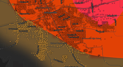
See exactly what you get.
Explore the full Springdale, AR Strike Map free – hail track, address overlay, and CSV download. No account required.
Try the Free Demo →