Balmorhea, TX Hail Storm – October 2026
October 26, 2026 hail storm near Balmorhea, TX. Radar-confirmed hail track and contractor lead lists available.
Max Hail
1.97"1.97" est.
confirmed
Zones
2
NWS alerts
Radar
2,089
dual-pol hits
Spotter
–
field reports
NWS WARNING AREA · Balmorhea Metro · Oct 26, 2026
Intelligence Platform
StormSnipe Pro
$49/ mo
Cancel anytime · No contracts
›All 50 states
›No zone limits
›No per-event fees
Subscribe to Pro
Pro renews monthly until canceled · Cancel anytime in the billing portal
What's included
Instant delivery
Every storm published within hours of NOAA confirmation.
Interactive Strike Map
Full radar-confirmed hail track on an interactive map.
Address CSV export
Every affected residential address, export-ready.
Smart alerts
Notified when a storm hits your area. Set zones once.
Nationwide coverage
All 50 states. No zone restrictions. No geographic caps.
Live pipeline
NOAA NEXRAD processed and delivered 24/7.
Address data notice
Pro coverage in California, Vermont, and Oregon includes the confirmed hail track and Strike Map only — no address lists. State data-privacy law treats compiled address lists differently in those three states, so we exclude their addresses from extraction and delivery.
NWS WARNING AREAS · 2
This storm generated 2 NWS alert zones. Pro access covers the complete storm track and all addresses across every zone.
ZONE 1NWS TXC371
Balmorhea, TX
Dual-Pol Radar
Alert issued Mon, Oct 26 · 10:28 PM UTC
1.97"
confirmed
1.65"
est. (NWS)
ZONE 2NWS TXC371
Fort Stockton, TX
Dual-Pol Radar
2 addresses in warning area
Alert issued Mon, Oct 26 · 11:16 PM UTC
1.32"
confirmed
1.97"
est. (NWS)
Balmorhea, TX – October 26, 2026: a late-afternoon into early-evening multi-cell storm produced hail tracked by dual-polarization radar, with stones approaching 2.0 inches in diameter.
What Happened
The event moved through the Balmorhea warning area in the late afternoon and into the early evening. NWS alerts tracked two distinct radar hail signatures during the event. At 5:28 PM CDT (22:28 UTC) dual-polarization NEXRAD detected hail near 1.65 inches. At 6:16 PM CDT (23:16 UTC) radar-detected hail signatures increased to roughly 1.97 inches. Storm coverage was patchy but produced concentrated hail cores as it crossed the warning area around Balmorhea. This page aggregates radar detections across the affected NWS warning area for the multi-zone event.
Damage Assessment
Stones in the measured range are larger than a golf ball (1.75 inches) and below a baseball (2.75 inches) on the NWS object scale. Where those stones fell, expect denting to vehicle body panels, cracked or shattered skylights, and localized loss of granules on asphalt shingle roofs, especially on older or weathered coverings. Metal roofing can dent, and exposed mechanical equipment such as HVAC condensers and solar panels are at risk of impact damage.
Roofing inspections should focus on hail patterning rather than uniform wear. Look for circular impact marks, punctures through softer coverings, and missing shingle tabs concentrated along the storm track indicated by radar returns. Glass damage is most likely on horizontal or near-horizontal panes and skylights. Yard-level items such as irrigation equipment, outdoor furniture, and parked vehicles in the direct hail cores may show the heaviest impact.
What Contractors Should Know
Prioritize safety and documentation. Use photos with timestamps and survey notes that reference the nearest cross streets or visible landmarks in Balmorhea. Start with high-priority assets: roofs showing punctures or open seams, rooftop mechanical equipment, and vehicles that are part of a business fleet. Temporary water diversion and tarping reduce secondary water damage ahead of permanent repairs.
For roofing crews, inspect for concentrated granule loss and point-impact bruising to the mat beneath shingles. Record hail diameter estimates alongside photographic evidence. Avoid assumptions about uniform damage across an entire property; the radar-detected cores indicate that impact was likely localized. Coordinate with property owners on insurance timelines and provide itemized repair scopes that separate hail-specific damage from preexisting wear.
See the Strike Map for the radar-confirmed hail swath produced during this event.
Storm Details
- Start Date
- Monday, October 26, 2026
- Last Activity
- Monday, October 26, 2026
- Location
- Balmorhea, TX
- Warning Areas
- 2
- Dual-Pol Radar
- 2,089
- Spotter Reports
- --
Preview Strike Map
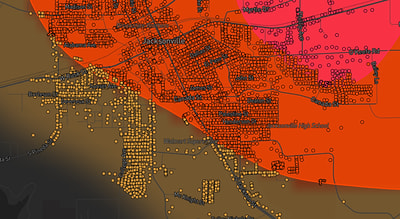
See exactly what you get.
Explore the full Springdale, AR Strike Map free – hail track, address overlay, and CSV download. No account required.
Try the Free Demo →