Caliente, NV Hail Storm – October 2026
October 21, 2026 hail storm near Caliente, NV. Radar-confirmed hail track and contractor lead lists available.
Max Hail
2.94"1.87" est.
confirmed
Zones
7
NWS alerts
Radar
1,440
dual-pol hits
Spotter
2
field reports
NWS WARNING AREA · Caliente Metro · Oct 22, 2026
Intelligence Platform
StormSnipe Pro
$49/ mo
Cancel anytime · No contracts
›All 50 states
›No zone limits
›No per-event fees
Subscribe to Pro
Pro renews monthly until canceled · Cancel anytime in the billing portal
What's included
Instant delivery
Every storm published within hours of NOAA confirmation.
Interactive Strike Map
Full radar-confirmed hail track on an interactive map.
Address CSV export
Every affected residential address, export-ready.
Smart alerts
Notified when a storm hits your area. Set zones once.
Nationwide coverage
All 50 states. No zone restrictions. No geographic caps.
Live pipeline
NOAA NEXRAD processed and delivered 24/7.
Address data notice
Pro coverage in California, Vermont, and Oregon includes the confirmed hail track and Strike Map only — no address lists. State data-privacy law treats compiled address lists differently in those three states, so we exclude their addresses from extraction and delivery.
NWS WARNING AREAS · 7
This storm generated 7 NWS alert zones. Pro access covers the complete storm track and all addresses across every zone.
ZONE 1NWS AZC015
Caliente, NV
Dual-Pol Radar
Alert issued Thu, Oct 22 · 5:07 AM UTC
2.94"
confirmed
1.7"
est. (NWS)
ZONE 2NWS UTC053
Ivins, UT
Dual-Pol Radar
558 addresses in warning area
Alert issued Thu, Oct 22 · 5:28 AM UTC
1.89"
confirmed
1"
est. (NWS)
ZONE 3NWS AZC015
Caliente, NV
Dual-Pol Radar
Alert issued Thu, Oct 22 · 5:32 AM UTC
1.75"
confirmed
1.87"
est. (NWS)
ZONE 4NWS UTC001
Milford, UT
Dual-Pol Radar
Alert issued Thu, Oct 22 · 8:02 AM UTC
1.17"
confirmed
1"
est. (NWS)
ZONE 5NWS UTC021
Pine Valley, UT
Dual-Pol Radar
Alert issued Thu, Oct 22 · 1:23 PM UTC
1.39"
confirmed
1.39"
est. (NWS)
ZONE 6NWS UTC001
Parowan, UT
Dual-Pol Radar
Alert issued Thu, Oct 22 · 6:50 PM UTC
0.89"
confirmed
1"
est. (NWS)
ZONE 7NWS NVC003
Moapa, NV
Dual-Pol Radar
Alert issued Thu, Oct 22 · 7:47 PM UTC
1.28"
confirmed
1.13"
est. (NWS)
Caliente, Nevada experienced a multi-zone hail event on October 21–22, 2026 that produced a peak 2.94-inch stone and multiple radar-detected signatures and NWS warnings. The event is concluded.
What Happened
The storm produced seven NWS alerts across a roughly 14-hour span beginning late evening on October 21 and continuing into the following afternoon. Initial radar detection occurred at 10:07 PM PDT on October 21 with a 1.70-inch radar-derived hail signature. An NWS warning-only alert followed at 10:28 PM PDT citing 1.00-inch hail. Radar again identified larger echoes at 10:32 PM PDT with a 1.87-inch signature.
Activity persisted overnight and into mid-morning. A radar-detected 1.00-inch signal was logged at 1:02 AM PDT on October 22. At 6:23 AM PDT radar indicated 1.39-inch hail signatures. Late morning at 11:50 AM PDT an NWS warning-only alert referenced 1.00-inch hail, and a final radar-derived detection at 12:47 PM PDT registered 1.13-inch hail.
Across the sequence, detections alternated between dual-polarization NEXRAD hail detection and NWS warning-only alerts. The pattern indicates multiple hail-producing cells traversed separate zones in and around Caliente between late evening and early afternoon. The event is no longer active.
Damage Assessment
Radar detections during the event spanned a practical range from roughly 1.00 inch up to stones near 3.00 inches across separate zones. Stones at the lower end of that range correspond to US quarter and golf-ball categories and commonly cause cosmetic vehicle damage and denting to aluminum and thin metal surfaces. Hail in the 1.75-inch (golf ball) to 2.75-inch (baseball) range increases the probability of shattered single-pane glass, broken skylights, and substantial dents to vehicle roofs, hoods, and trunk lids.
Stones approaching the 3.00-inch scale pose a higher risk to roof coverings, particularly older or mechanically fastened asphalt shingles, clay tiles, and agricultural coverings. Expect localized structural compromise where large stones impacted exposed decking or older roofing systems. Where radar-detected signatures clustered over developed parcels in Caliente, elevated risk exists for exposed vehicles, rooftop-mounted equipment, and small outbuildings.
What Contractors Should Know
Prioritize a documented triage. Begin with external inspections for broken glass, punctured skylights, and areas of roofing with missing or fractured shingles. Photograph all findings with location references and time-stamps. Use temporary tarping only where decking is exposed. Secure permits and use fall protection when working on pitched or tiled roofs.
Order materials early for shingles, flashing, and underlayment replacements. Inspect HVAC condensers, solar panels, and antenna mounts for dents and misalignment. For insurance-ready repairs, provide clear before-and-after imagery and itemized repair estimates tied to specific addresses. For broader planning, coordinate crews to cover multiple small-loss locations in the immediate Caliente area rather than staging for single large-loss jobs.
Storm Details
- Start Date
- Wednesday, October 21, 2026
- Last Activity
- Thursday, October 22, 2026
- Location
- Caliente, NV
- Warning Areas
- 7
- Dual-Pol Radar
- 1,440
- Spotter Reports
- 2
Preview Strike Map
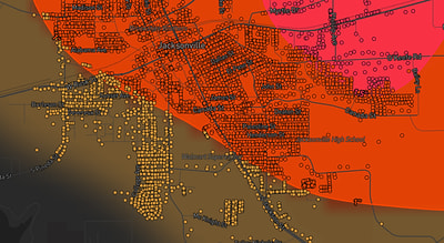
See exactly what you get.
Explore the full Springdale, AR Strike Map free – hail track, address overlay, and CSV download. No account required.
Try the Free Demo →